The flight from Chengdu to Lhasa showcases the stunning natural beauty of the region. As you fly, the cityscape fades, revealing picturesque valleys and lush forests against rugged peaks. The Himalayas' magnitude and untouched wilderness beneath mesmerize. Approaching Lhasa, arid plains contrast with earlier landscapes, creating a beautiful, vast Tibetan plateau. This flight offers a unique opportunity to witness the world's natural splendour and ignite a sense of wonder.
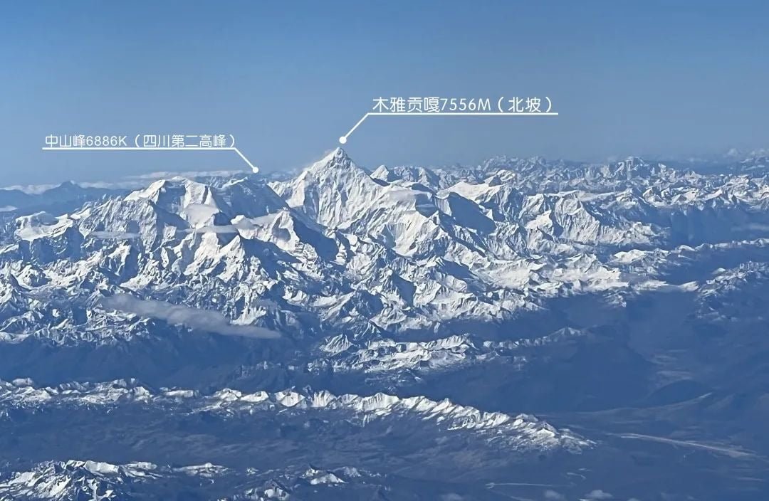
Muya Gongga is the highest peak in Sichuan (7556 meters above sea level). The north slope of Gongga Mountain is pyramid-shaped And Zhongshan Peak, the second-highest peak in Sichuan (6886 meters above sea level)
#image_title
About 30 minutes after leaving Chengdu, you will catch a glimpse of Muya Gongga, also known as the King of Shu Mountain, outside your window. The first sight that greets you is the east slope of Mount Muya Gongga. Unlike the north slope, the east slope does not possess a regular triangular shape. However, due to its position as the windward slope of the basin, the chance of witnessing a sea of clouds on the mountainside is higher. Additionally, when looking towards the east slope, you can still observe the three pin-shaped snow-capped mountains in the distance. These are the renowned Daocheng Sanshen Mountains, which we will explore later on.
#image_title
Yala Snow Mountain, standing at 5884 meters above sea level, is the second prominent peak following Muya Gongga Mountain. It is visible from the wings of an aeroplane and is often observed by tourists exploring western Sichuan, particularly in Tagong Grassland. The Tagong Grassland lies behind the Yala Snow Mountain in the photograph. When viewed from the plane, it presents a distinct contrast to the lotus-shaped snow-capped mountains on the ground.
#image_title
After 50 minutes of flying, we will encounter a deep gorge. This marks the initial significant branch of the Yangtze River in Panzhihua, known as the Yalong River. Recently measured, its length has surpassed that of the Hanshui River, making it the longest tributary of the Yangtze River. Is the mountain in the photograph very lush? The Yalong River boasts excellent vegetation. Hence, it is also the Yangtze River's major tributary with the lowest sediment concentration.
Furthermore, if we look closely, we can spot three towering snow-capped mountains. These are the pin-like peaks of the Sanshen Mountain in Daocheng. To highlight the relationship between the Yalong River Valley and Daocheng Sanshen Mountain, we have included vertical images below. Let's take a closer look.
#image_title
there is a proverb that individuals trust "If you have affection for somebody, take her to Daocheng. If you despise somebody, take her to Daocheng"
On the aeroplane, we don't fret about adoration and disdain, gaze at those three eminent mountains of Daocheng and retain their names, Manjusri Bodhisattva Yang Maiyong is 5958 meters above ocean level, Guanyin Bodhisattva Xiannairi 6032 meters, Vajrapani Charang Dorje 5958 meters.
#image_title
After crossing the Yalong River, you will reach Litang, the birthplace of the seventh Dalai Lama, and the renowned Genie Mountain (6240 meters above sea level). Nearby, you can find the Maoya Grassland, with the majestic Meili Snow Mountains in Yunnan visible in the distance.
#image_title
After Litang, there is Batang, which is on the verge of departing from Sichuan and entering Tibet.
The Shaluli Mountains nearby are covered in snow, while the Meili Snow Mountain towers in the distance. In the centre lies a deep valley that separates the terrain. That is our maternal river, the Jinsha River, flows in the upper reaches of the Yangtze River.
#image_title
After traversing the Jinsha River and venturing into Tibet, The Meili Snow Mountains became more apparent, The primary summit of Meili Snow Mountain, Kawa Karpo (6740 meters above sea level) is likewise the principal summit of the entire Mountain Range, also serves as the dividing peaks between Tibet and Yunnan and It holds the distinction of being the tallest peak in Yunnan Province.
#image_title
Taniantaweng Ranges and Mangkam Ranges, Shaluli Range (Powor Gang) Gangkar Range (main summit Gongga) are part of the Hengduan Ranges. The ranges of Hengduan are running alongside the major waterway, the Yalong River in Sichuan, and the Jinsha River on the Sichuan-Tibet border.Lancang River, the upper section of the Mekong River, is The first major river seen in Tibet, It flows through six nations including China, Myanmar, Laos, Thailand, Cambodia and Vietnam. Soaring above the Lancang River, a mountain meadow came into view. This is the Bangda Grassland, the very place where Chamdo Airport is situated.
#image_title
After your flight for 1 hour and 30 minutes. The highest point in Tibet, Namjagbarwa Peak (7782 meters), comes into view. Rising above the clouds, it stands out with its identifiable curved ridge. Namjagbarwa is located amidst the moisture from the Indian Ocean.
On the main road leading north to the Qinghai-Tibet Plateau, perpetual clouds and mist almost always obscure the mountainside. However, if you observe closely, you will notice that the cloud cover rests on the ground. It is quite difficult to catch a glimpse of it, but this is because the mountain is elevated enough to reach the Sky. Even from an aircraft, which is significantly higher above the ground, the chances of spotting Namjagbarwa are still quite high. This mountain is considered the most picturesque among the top ten snow-capped mountains in China.
#image_title
After witnessing Namjagbarwa, we draw nearer to the city of Lhasa. In the fortunate event of spotting an aircraft to modify its position, one may catch a glimpse of the region of Shannan and the towering Nojin Kangsang Peak (at an elevation of 7191 meters above sea level), as well as the majestic Himalayas in the distance.
#image_title
Yamdrok Yongtso, one of the sacred lakes in Tibet, is located at the base of Nojin Kangsang Peak. It resembles Qiandao Lake in shape and is accompanied by Luozha County, Shannan. Recently, the popular trend of self-driving has been revolving around Kula Gangri Snow Mountain, which stands at 7538 meters above sea level.
#image_title
As we marvelled at the snow-clad peaks and sacred lakes, we soared over the Potala Palace. When the aircraft descends and veers left, the Lhasa River merges with the Yarlung Zangbo River outside the window, forming a visible confluence. At this moment, the duration of your flight feels insufficient as Lhasa Gonggar International Airport awaits ahead.
#image_title
There are numerous methods to reach Tibet, such as taking the train and traversing the Qinghai-Tibet Railway. You can also opt for self-driving, motorcycle travel, cycling, or hitchhiking on the National Highway numbers 318, 317, 214, 109, and 219
Each approach offers different perspectives and experiences. Nevertheless, there is no denying that flying into Tibet is the most convenient means of entry. Travelling from Chengdu to Lhasa by air allows you to witness the breathtaking natural wonders of the Qionglai Mountains, the Daxue Mountains, the Shaluli Mountains, the Hengduan Ranges, and the Nyachen Tanglha Mountains.
You will also soar above the Minjiang River, Qingyi River, Dadu River, Yalong River, Jinsha River, Nu River, Lhasa River, and Yarlung Tsangbo River
There is no other place in the world with such a concentrated display of natural beauty. Perhaps only those who fly over Mount Everest on the Lhasa-Kathmandu route can compare to this magnificent flight path.
https://tourtraveltibet.com/natural-splendor-of-chengdu-to-lhasa-flight-most-beautiful-snow-peaks-in-china/
Comments
Post a Comment